 look news india

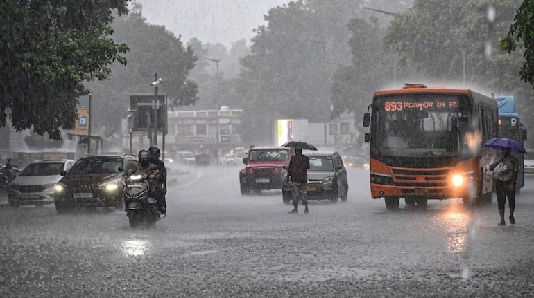
The impact of the extremely severe cyclonic storm ‘Arnab’, active in the Bay of Bengal, is now crossing the boundaries of the coastal states and moving rapidly towards the plains of Uttar Pradesh, the largest state of North India. According to the latest forecast of the Indian Meteorological Department (IMD) and Zonal Meteorological Center Lucknow, after making landfall on the coasts of Andhra Pradesh and Odisha on October 28, this cyclonic system will weaken and enter the border of Uttar Pradesh via Central India. Due to its effect, the weather will completely change in the eastern and central parts of the state after the next 24 hours i.e. from late evening of 28th October. On October 29 and 30, many parts of the state will see thunder, strong gusty winds and torrential rains. Due to this unexpected unseasonal rain, there will be a sharp drop of 5 to 8 degrees Celsius in the maximum day temperature in the state, due to which the pink cold will arrive before time.
The Meteorological Department has issued a special ‘Orange Alert’ for the districts connected to the southern and eastern ends of Uttar Pradesh. Heavy moisture laden winds coming from the Bay of Bengal will first hit Vindhya and Purvanchal region:
-
Most affected districts: Sonbhadra, Mirzapur, Chandauli, Varanasi, Prayagraj, Chitrakoot, Sant Ravidas Nagar (Bhadohi), Ghazipur and Ballia.
-
Wind speed and lightning: In these districts, there is a possibility of strong surface winds at a speed of 40 to 50 kilometers per hour and severe thunder along with lightning strike in these districts from the night of 28th October.
-
Threat of extremely heavy rain: ‘Extremely Heavy Rainfall’ is expected at some places in Sonbhadra and surrounding areas on October 29, which may create a threat of water logging in low-lying areas and overflowing of rivers and drains. The administration has instructed the District Magistrates and disaster management teams of all these districts to be ready 24 hours for any emergency.
The impact of the clouds of storm ‘Arnab’ will be clearly felt in the entire Awadh region including Uttar Pradesh capital Lucknow, Kanpur city, Barabanki, Ayodhya, Rae Bareli, Unnao and Sultanpur.
-
Condition of Lucknow: There will be movement of clouds throughout the day in Lucknow on 28th October, whereas from the morning of 29th October the sky will be covered with dense dark clouds. Cold winds will blow at the speed of 30 to 45 km/hour in Hazratganj, Gomti Nagar, Alambagh and surrounding areas and intermittent moderate to heavy rain will begin.
-
Sharp drop in temperature: Due to the combined effect of rain and moist easterly winds, the maximum temperature in Lucknow and Kanpur may fall to around 25 to 26 degrees Celsius. Due to lack of sunlight during the day and continuous cold winds at night, people will suddenly start feeling the need of warm clothes.
In Western Uttar Pradesh (Meerut, Ghaziabad, Noida, Bulandshahr, Bareilly, Moradabad), the impact of the cyclone will not be as aggressive as Purvanchal, but change in weather will be visible here also. On October 29 and 30, due to the confluence of a weak western disturbance and cyclonic winds, the sky over western UP will also be cloudy with fog and light to moderate clouds. There are chances of sporadic drizzle or light showers at some selected places. Due to strong winds, there is a possibility of some relief in the dust, smog and toxic pollution (AQI) accumulated in the cities of NCR and Western UP.
At present, the busiest and most sensitive phase of harvesting of Kharif crops and sowing of Rabi crops is going on in the rural areas of Uttar Pradesh. At such a time, unseasonal rains caused by cyclone ‘Arnab’ can prove to be a huge disaster for farmers:
-
Damage to ripe paddy crop: Paddy harvesting is going on in the fields of the state and lakhs of quintals of the crop are lying harvested in barns or fields. Paddy lying in the open is at serious risk of getting wet, rotting and grain loss due to heavy rains and storms of up to 50 km/hour.
-
Potato and mustard sowing affected: Farmers who have recently sown early potatoes and mustard are likely to see the seeds rotting due to water logging in their fields and the cost of re-sowing may increase.
-
Strict advisory from Agriculture Department: The State Agriculture Department has given strict instructions to the farmers to cover the harvested crops safely with tarpaulin or transport them to permanent warehouses within the next 24 hours. Also, immediately stop any kind of irrigation or spraying of pesticides in the fields for the next 3-4 days.
The Uttar Pradesh Relief Commissioner’s office has issued instructions to all district magistrates to be proactive and monitor waterlogging, power supply and health services. General citizens have been advised to:
-
Avoid traveling in bad weather: Avoid non-essential travel on highways or rural roads during heavy rain and thunderstorms on October 29 and 30.
-
Stay away from trees and hoardings: Do not stand under large old trees, weak tin sheds, hoardings and electric poles during strong storm winds.
-
Protection from lightning: When lightning strikes in rural areas, people working in open fields should immediately take shelter in pucca houses and stay away from direct contact with mobile phones or metal objects. For any kind of emergency, the relief helpline number 1070 of Uttar Pradesh government can be contacted.