 look news india

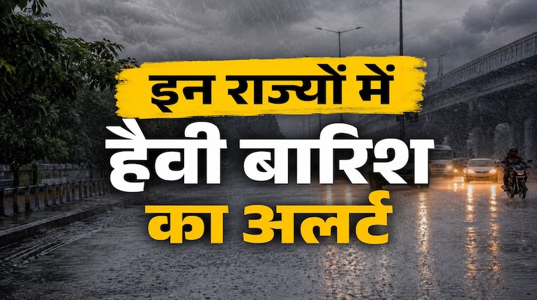
The Indian Meteorological Department (IMD) has today released a new and detailed National Weather Bulletin for June 17 regarding the country’s weather. Due to the continuously increasing speed of South-West Monsoon and new weather systems active in the sky, very aggressive weather conditions will be seen in many parts of the country today. The Meteorological Department has issued an alert of heavy to extremely heavy rain in Bihar, Sub-Himalayan West Bengal and North-Eastern states. At the same time, serious warnings have been given in more than 16 states including Delhi-NCR and Uttar Pradesh regarding thunderstorms and lightning with a speed of 50 km/hour.
Storm will hit these 16 states including Delhi-NCR at a speed of 50 km/hour.
According to IMD, a large part of the country will be affected today by thunder, lightning and strong winds with a speed of 40 to 50 km/hour. Many states of North, Central and South India will be affected by this thunderstorm activity:
-
North and Central India: Delhi-NCR, Haryana, Chandigarh, Punjab, Western Uttar Pradesh and Madhya Pradesh.
-
Eastern and North-Eastern India: Bihar, Jharkhand, Odisha, West Bengal and Sikkim.
-
South and West India: Telangana, Vidarbha (Maharashtra), Chhattisgarh, Coastal Andhra Pradesh, Tamil Nadu, Puducherry and Karaikal as well as Andaman and Nicobar Islands.
Today the weather will change suddenly with thunderstorms in all these states, which is expected to provide some relief from the scorching temperatures.
Red alert of torrential rain in Bihar and Bengal, tornado in Rajasthan
There are going to be torrential monsoon and pre-monsoon rains in many states of the country today. A red alert has been issued for heavy to very heavy rainfall in Sub-Himalayan West Bengal and Sikkim today. A new phase of heavy rains is starting in Bihar from today which will continue till June 20. Apart from this, there is a strong possibility of heavy rain at different places in Assam, Meghalaya and Kerala today.
On the other hand, the Meteorological Department has issued a special warning for Rajasthan. Today, a severe tornado moving at a speed of 50 to 60 km/hour may occur in different areas of Rajasthan. Also, there is a possibility of dust storm in western Rajasthan till June 19, due to which visibility may be significantly reduced.
Heat wave will also affect Uttar Pradesh and Madhya Pradesh, humidity will make you miserable
On one hand, half of the country will be surrounded by storm and water, while on the other hand, heat wave will continue in some states. Today, there is a possibility of severe heat wave in some parts of Eastern Uttar Pradesh, Madhya Pradesh, Chhattisgarh, Telangana and Vidarbha. In eastern Uttar Pradesh, there is a possibility of rain on June 21-22 after heat wave on June 17-18. However, there has been a warning that a new round of severe heat wave will start again in western Uttar Pradesh between June 19 and June 22. Apart from this, people in coastal Andhra Pradesh, Odisha and Goa will suffer from the humid heat.
Monsoon Tracker: Monsoon will enter these states in the next 4-5 days
According to the Meteorological Department, the Northern Limit of Monsoon (NLM) currently rests over Harnai, Solapur, Hyderabad, Bhadrachalam, Ranchi, Jamui and Muzaffarpur. A seasonal trough line is extending from Punjab to Bihar through Haryana and Uttar Pradesh. Under its influence, conditions are completely favorable for the advance of monsoon into remaining parts of Telangana, Odisha, Jharkhand, Bihar and some more areas of Chhattisgarh within the next 4-5 days.