 look news india

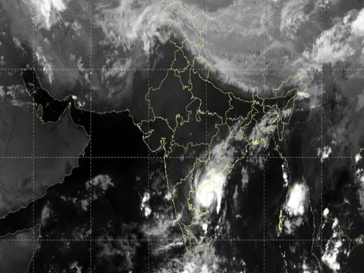
At present, news of a very big and worrying natural disaster is emerging from the eastern coastal areas of India. Severe cyclonic storm has been becoming increasingly active in the Bay of Bengal since last few days. ‘Murasu’ (Cyclone Murasu) This morning it hit the coast of Andhra Pradesh with full force. According to the India Meteorological Department (IMD), the cyclone crossed the coastal areas of Nellore and Narsapur near Ongole in the early morning, causing devastation on the coastal strips. During landfall, the wind speed was recorded at 100 to 110 km per hour, which was increasing at times to 120 km/hour. Due to this severe storm, the weather has completely deteriorated in many states including Andhra Pradesh, Telangana, Chhattisgarh and Tamil Nadu. In view of the conditions like heavy rain, strong storm and flood, the administration has started relief and rescue operations on war footing. Let us know in detail where and in what form the current impact of Cyclone Murasu is visible.
Murasu hits Andhra Pradesh coast: Strong winds and torrential rains cause devastation
According to the Meteorological Department bulletin, Severe Cyclonic Storm Murasu crossed the coast of South Coastal Andhra Pradesh between 03:30 and 05:30 am today. At the time of landfall, its center was located near Ongole, southwest of Bapatla and west-southwest of Machilipatnam. Meteorologists say that this storm is now moving towards north-northwest direction and is gradually weakening.
After hitting the coast, huge devastation has been seen in districts like Bapatla, Prakasam, Nellore, Krishna, Guntur and West Godavari. Here, winds blowing at a speed of 100 to 110 km per hour have blown away the roofs of kutcha houses, while at many places the supply has come to a standstill due to uprooting of heavy trees and electric poles. Standing crops of paddy, banana, papaya and coconut plantations have been heavily damaged, causing months of hard work of farmers to be wasted. The Meteorological Department estimates that by noon the wind speed will reduce to 70-80 km per hour and by midnight today it will completely weaken into a depression.
Heavy impact on rail and air traffic: Dozens of trains and flights cancelled.
Due to this severe cyclonic storm and bad weather, life has become completely disrupted. As a precautionary measure, South Coast Railways has canceled several important trains due to security reasons, severely affecting rail traffic between Vijayawada, Gudur, Guntur and Tenali. Movement of trains had to be stopped due to waterlogging and falling of trees on the railway tracks.
It has also had a deep impact on air traffic. At least 19 domestic flights operating from Vijayawada, Tirupati and Visakhapatnam airports in Andhra Pradesh have been cancelled. Apart from this, about 11 flights from Chennai Airport, the capital of neighboring state Tamil Nadu, also had to be canceled due to bad weather. Airlines have appealed to passengers to check the status of their flights before leaving for the airport.
Alert of heavy rain in many states including Telangana, Chhattisgarh and Tamil Nadu
Due to the impact of Cyclone Murasu, heavy to very heavy rains have started not only in Andhra Pradesh but also in many other southern and central states of the country. The Meteorological Department has issued a red alert for the coastal areas of Andhra Pradesh and North Tamil Nadu.
-
Telangana: An alert of torrential and extremely heavy rain has been issued in many districts of the state today. Flood-like situation may occur in low-lying areas of Nalgonda, Nagarkurnool and Suryapet.
-
Chhattisgarh and Odisha: Due to the cyclone moving northwards, many areas of South Odisha and Chhattisgarh are also likely to record moderate to heavy rainfall on November 3 and 4.
-
Tamil Nadu: Scattered heavy rain with gusty winds of 60 to 70 kmph is expected in Chennai, Kanchipuram and Tiruvallur districts.
Danger of flash flood (sudden flood) and scary waves in the sea
The Meteorological Department and Disaster Management Authority have warned that there is a serious risk of flash floods and heavy waterlogging in many areas during the next 24 hours. People may have to face huge problems due to water logging in low-lying areas of Guntur, Krishna, Eluru, Palanadu, Prakasam and Nellore districts of Andhra Pradesh.
The situation at sea remains extremely dangerous. Storm waves 9 to 14 meters high are rising along the coasts of West-Central Bay of Bengal and Andhra Pradesh. During high tide, sea waves 1.0 to 1.5 meters higher than normal may enter coastal settlements, forcing people living in low-lying areas to be evacuated to safer places.
Strict instructions from the administration: Advisory for fishermen and citizens
The administration is fully prepared in view of the dangerous cyclone. Fishermen have been given strict instructions not to venture into the Bay of Bengal and surrounding coastal areas till the afternoon of November 4. People living in coastal and dilapidated houses are being evacuated and shifted to safe shelter homes.
The government has appealed to citizens not to leave their homes unless absolutely necessary. While travelling, stay away from waterlogged roads and weak trees or power poles. The local administration is fully prepared to deal with any emergency and relief and rescue teams have been deployed in the affected areas.