 look news india

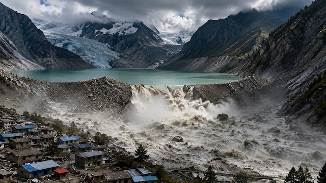
The terror of the devastation caused by the recent horrific flash flood in Nepal and the adjacent Tibet region, situated in the lap of the Himalayas, had not yet subsided when another big crisis has left both the countries breathless. China’s Ministry of Water Resources and emergency management agencies have sent an extremely urgent and emergency warning to the Government of Nepal through diplomatic channels. According to the warning, a massive avalanche and accumulation of heavy debris following the breaking of the glacier has formed a huge ‘temporary barrier lake’ in the high mountain area of the border.
A huge pressure of millions of cubic meters of water has built up in this lake. If this natural dam made of debris suddenly breaks, there could once again be a devastating flood in the rivers flowing downstream. As soon as this serious alert came to light, Nepal’s Home Ministry and Disaster Management Authority have issued a high alert in the lower plains of Bhotekoshi, Trishuli and Narayani rivers and have instructed thousands of citizens living on the river banks to immediately move to higher places.
According to geologists and high-resolution satellite imagery, the disaster was not triggered by heavy rains, but by the sudden collapse of a giant part of the Langtang Lirang Glacier at an altitude of about 5,200 meters. This huge mountain of ice, rocks and boulders falls 1,200 meters into the narrow valley of the Lhende River.
This huge debris formed a natural dam, which opened Chochen in the Tibet region of China and completely stopped the flow of water at the confluence of the Purepu Tsangpo rivers along the Nepal border. Within a few hours, more than 25 lakh cubic meters of water accumulated there due to the water drain being stopped. Chinese scientists estimate that if the amount of glacier melt and water coming from above continues to increase, then this lake can break the embankment at any time and flow downwards with great speed.
Due to the fear of the lake bursting, at least five big districts of Nepal – Rasuwa, Nuwakot, Dhading, Gorkha and Chitwan – are in direct danger. The Lhende River further joins the Bhotekoshi and Trishuli rivers, passing through Nepal’s major hydropower and economic corridor.
-
Huge threat to hydropower projects: Many under construction and operating power plants including Upper Trishuli-1 Hydropower Project have been immediately closed down due to safety reasons. Hundreds of laborers and engineers working in the tunnel and power house have been evacuated to safe places.
-
Surveillance in Devghat and Chitwan: The previous flood flow was recorded at a record level of 5,850 cubic meters per second at Devghat, causing the Narayani river to swell. In view of the new danger, continuous warnings are being issued through sirens and loudspeakers in coastal ghats and settlements.
-
Connectivity of bridges and roads halted: The important Friendship Bridge and parts of border highways connecting Nepal and China have already been washed away in previous flash floods. Trade and land connectivity between the two countries has been completely blocked due to the fear of new floods.
This disaster has seriously affected not only Nepal but also the Tibet Autonomous Region of China. Jilong port across the border—the largest trading hub between Tibet and Nepal—was buried under a blanket of debris and mud several feet thick. Special military helicopters were deployed to evacuate hundreds of Chinese citizens and foreign pilgrims from there.
On the instructions of Chinese President Xi Jinping, the Chinese Engineering Corps (China Anneng) has deployed special radar systems and high-altitude drones to monitor the actual situation of the lake. 3D modeling of the lake’s water level, debris leakage and water flow patterns is being done. Chinese experts have informed Nepali authorities that they have activated an early warning system, so that if the lake’s dam breaks, an alert can be sent about 20 to 30 minutes before the water reaches the downstream areas.
Environmental experts and scientists of the International Center for Integrated Mountain Development (ICIMOD) have called this incident an alarming sign of climate change. The Hindu-Kush Himalayan region is warming almost twice as fast as the global average, causing glaciers at high altitude to melt and weaken faster.
According to scientific studies, the number of risky glacial lakes in the Himalayan region has increased from 1,900 to more than 2,600 since 2005. Glacial Lake Outburst Floods (GLOFs) and massive ice-rock avalanches are now more unpredictable than ever. This is the second such major incident in the same region in the last fourteen months, highlighting the weaknesses of the cross-border disaster management system.
Extensive search and rescue operations by Nepal’s Army, Armed Police Force (APF) and police have been temporarily halted in sensitive river-bed areas following China’s fresh warning. Officials say that the lives of rescue teams cannot be put at risk.
The local administration has issued a strict advisory for residents of the affected areas:
-
Do not under any circumstances go to the banks of rivers, to extract sand or to fish.
-
Avoid sleeping in houses built near river beds at night and take shelter in nearby community shelters.
-
If the color of the river water suddenly turns brown or the water level suddenly increases or decreases, immediately inform the local police and administrative control room.
-
Avoid unverified rumors on social media and rely only on national radio, TV and official disaster management bulletins.
Technical teams from Nepal and China are jointly considering measures to normalize the situation and drain out the lake water in a controlled manner. However, until this accumulation of natural debris is completely cleared, the danger of flood in this Himalayan valley remains the same.